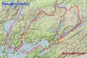
This route through the Superior National Forest offers a little bit of everything. It includes big water lakes, winding creeks, challenging portages, waterfalls, sandy beaches, and scenic overlooks. It’s a great route for groups that want a challenging experience without having to travel a large number of miles every day.
[singlepic=351,320,240,,left]The thirty mile loop begins in the North Arm of the historic Burntside Lake, then turns east into Little Long Lake. A mile-long portage, the longest of the trip, connects Little Long Lake and Bass Lake. From there, groups will either set camp on Bass Lake, or portage up to the more private High Lake. A set of fun and challenging hiking loops (3-9 miles) around Bass Lake and Dry Lake feature many gorgeous overlooks before ending at Dry Lake Falls. The canoe route than continues north through Low Lake and into the Range River, where it turns east into Grassy Lake. From there, a set of portages will bring groups through Tee Lake, Sletten, Little Sletten, Fenske, Everett, and Twin Lakes. A short but pretty paddle down the Dead River and back into Burntside completes the loop.

